The October 22, 2021issue of CounterPoint online magazine has an interesting article by George Wuerthner titled “The Dixie and Bootleg Fires : Examples of Failed Forest Policy.” https://www.counterpunch.org/2021/10/22/dixie-and-bootleg-fires-examples-of-failed-forest-policy/ Part of what makes this article so interesting are the many “before and after” photographs of burned over areas. I don’t know anything about the Mr. Wuerthner’s qualifications for making a “scientific” pronouncement upon what he observed, but he certainly raised interesting questions that demand answers.
Just as a happenstance, my wife and I drove through the area to the west of Chester on the way to our cabin at Lake Almanor yesterday. While the author was correct that the more managed parts didn’t appear to control the fire, he didn’t discuss what I thought was the most sticking aspect. Hwy 36 goes through about 20 miles of burned area to the west of Chester. That includes sections of relative old growth (24 to 36 inch trees) and sections of newer growth (8 to 16 inch trees). The old parts are in national park lands (Lassen) and the other part appear to be on timber company land (perhaps some overlap). The new part had been highly managed – before the fire it had been “raked” and kept free of brush and smaller trees. No large trees are in that area because it had been clear cut and replanted.
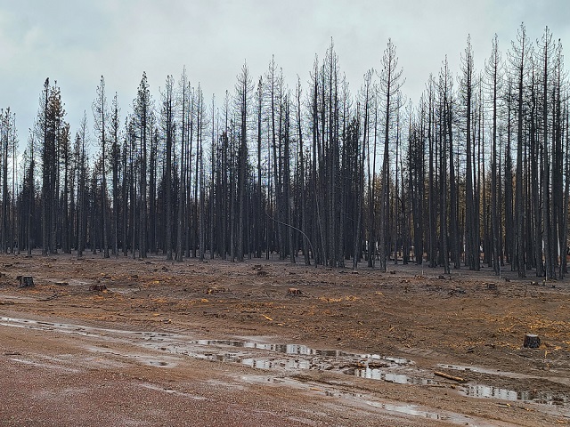
The experience of driving through that section of road was amazing. The old, brushy parts have a mix of burned out brush, and brush untouched by fire, with almost no obviously killed trees. All of the bigger trees looked fine, the areas that had burned brush were already regenerating (after only 2 months), and all looked pretty good. There is clearly a lot of remaining habit for animals. The other part consists of vast forests of dead 12 inch trees sticking up from totally bare ground – with the burned out clear cut areas showing in the background. There is close to zero habit or cover remaining in these areas. It is pretty obvious, where the trees are bigger the fire was smaller – and appeared to just open up some areas. It looks good and healthy. The parts that are managed and clearly all the same age are totally gone. Just dirt and rocks remain. The photos in the story fail to capture the distinction between heavily managed forests and those that have had time to grow “wild” since the last great logging operation 50 or 60 years ago. There is no “old growth” forest visible from the road.

Most of the “extreme” fire damage occurred to plantations of small, recently planted trees that had been extensively “managed” to eliminate the fire danger. These trees have almost all been killed by the fire. Areas with larger (older) trees, and a mix of trees and brush have very little fire damage to the trees. In these areas, most of the fire was low to the ground, cleaning out brush but leaving the more mature (and highly fire resistant) trees intact. The large plantings of new trees to support future logging is the situation that caused the large loss of buildings on the Paradise fire during the previous year, and that destroyed the town of Greenville. The residents of Greenville had been assured that by extensively “managing” the surrounding forest they would be protected from fire danger. However, managing meant clear cutting and replanting with new identical trees in the style of a plantation, resulting in out of control spread of high intensity fire and the destruction of the town.

Part of the fallacy of the story of the Indians burning the forests the assumption that they burned ALL of the forest. They didn’t do that, they burned small parts for specific purposes. For example, an area that might have the resources to grow sweet grass for making baskets would be burned to keep it clear from invading brush. An area that got to brushy to travel through might be burned. Not the whole damned forest, just the two acre sweet grass plot or the brush patch. They were “farmers” who used fire instead of a plow in many instances, but they didn’t burn it all or burn it indiscriminately. What they didn’t do was burn it as an excuse to cut all of the big trees down and they didn’t haul all of the carbon out of the forests to be cut into lumber and burned as “bio-fuel”.
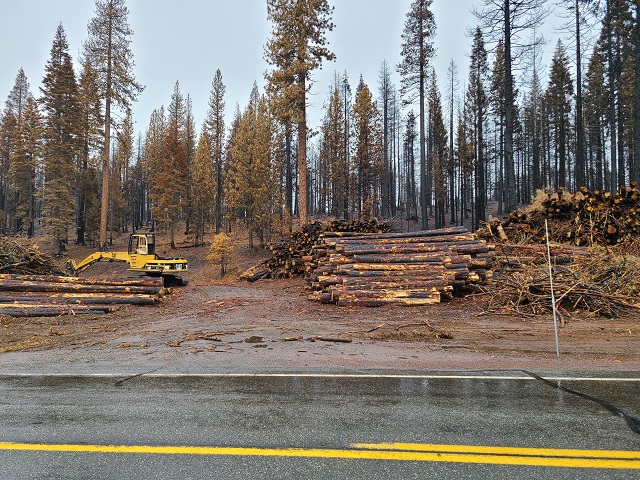
One thing about the drive along hwy 36 that really stands out is that they created a swath about 1000 feet along both sides of the road where they clear cut and logged out everything, ground up the remainder and let a 20 mile long desert with a road through the middle of it. Tens of thousands of trees were cut for timber, all of which had been “protected” because of the national park. My guess is that not only did they get the trees, but they got paid to get them out of there ASAP. I suppose it makes sense to clear a “safety corridor” for evacuation purposes, but they really did it big time. It would be interesting to “follow the dollar” on that operation. They did this along all of the roads in the fire area – hundreds of miles of roads through “protected” areas. When we were up here at the lake in September the roads were the biggest logging operation I had seen or contemplated – loggers were thick. Now they are gone, along with the trees. The machines that remain are gathering up all of the leftovers and grinding it up, resulting in deep layers of ground up material that prevents much of anything living in that area for the next few years. It is a well managed, mulched landscape – kind of like what you find around assisted care facilities where the old go to die. A few plants for color, all mulch to minimize weeds and anything “wild” from intruding.